Rincon, Puerto Rico Surf Forecast – August 18, 2015
We finally have a tropical system with some potential!
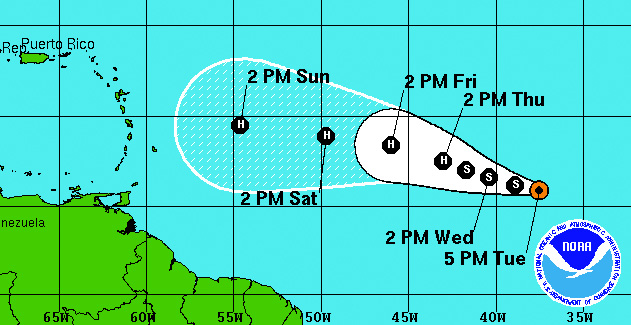
Don’t everyone look at it at the same time. We don’t want to scare it away. Tropical Storm Danny has formed in the open Atlantic between us and Africa. I was looking at the wind shear maps a few days ago and noticed that a small bubble of light shear was starting to form right about where Danny is right now and where he’ll be in another couple of days. If that sticks he might form into a Hurricane as currently forecast. As far as waves are concerned his track is currently set to take the low road underneath PR. If this happens he will most likely to be sheared apart the closer he gets to the island, but he’ll give a solid push of swell at the southeast. He’ll be a big enough system to make some swell on the north side of the island as well due to the pressure gradient and movement of the system. We have a high chance of surf one way or another from this system for just about every part of the island except Rincon.
What do we have to look forward to in Rincon?
Well the dream scenario is that Danny takes the high road and then parks just north of the Bahamas and goes cat 5 only to retrograde east southeast before going out to sea. There is about a .000000001% chance of that happening. If it did it would be EPIC. Rincon would turn into Indo. But let’s focus on reality. I’m seeing plenty of activity on satellite imagery off the eastern coast of the US. Nothing major, but there should be enough weather to keep a knee to waist high longboard wave pointed at Rincon for a few days to come. The lower tides will be best to welcome the tiny background swell. This week has been great for surf lessons so far and it looks to continue for a few days.
We’re heading into September, if it’s gonna happen – it’s gonna happen now.
Between now and the end of September is when the tropics peak. If we’re gonna see any action, now is the time it will happen. Fix any dings in your boards and get an early prep for the season. We might actually get to surf some real waves before November.
Today
NOAA WaveWatch III Wave Model:

Forecast Swell Period:

Forecast Winds:

Fri
NOAA WaveWatch III Wave Model:

Forecast Swell Period:

Forecast Winds:

Sat
NOAA WaveWatch III Wave Model:

Forecast Swell Period:

Forecast Winds:

Sun
NOAA WaveWatch III Wave Model:

Forecast Swell Period:

Forecast Winds:

Mon
NOAA WaveWatch III Wave Model:

Forecast Swell Period:

Forecast Winds:

Tue
NOAA WaveWatch III Wave Model:

Forecast Swell Period:

Forecast Winds:

Wed
NOAA WaveWatch III Wave Model:

Forecast Swell Period:

Forecast Winds:

Thu
NOAA WaveWatch III Wave Model:

Forecast Swell Period:

Forecast Winds:


