Rincon, Puerto Rico Surf Forecast – Feb 14, 2017

Massive winter storm means major swell event for Rincon, Puerto Rico.

Massive winter storm: major swell event for Rincon, Puerto Rico.

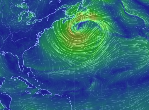
This storm is a beast! Look at all that wind field! It’s beautiful! I am so amped looking at the graphical representation of the winds this morning. Looking at the pressure chart is impressive too. This swell is going to crank for several days. We should see the first arrival on Wednesday afternoon or evening with some south winds on Wednesday and Thursday. This means that north facing beaches will be all time on these two days. This also means that there will be several spots working that normally get blown out right away. Your chances of surfing with a light crowd are very high if you know where to go. If you cram into the same exact peak as everyone else that’s on you. That being said, remember too that this is a major swell and we will see sets in the double overhead range and possibly bigger. If it’s out of your skill level don’t paddle out. If you see someone in trouble, help them if you can. Please be safe!

Early Weekend Outlook:

We should continue with head high surf through the weekend. The swell angle is supposed to remain out of the NW and even though the period drops a little, the NW angle hits Rincon and several other parts of Puerto Rico very well. I don’t anticipate it getting any smaller than waist to chest and just about every day should still have head high sets.

Today

NOAA WaveWatch III Wave Model:

Wave Watch III from NOAA wave prediction model for surfing Puerto Rico.

Forecast Swell Period:

Forecast Winds:

Wed

NOAA WaveWatch III Wave Model:

Wave Watch III from NOAA wave prediction model for surfing Puerto Rico.

Forecast Swell Period:

Forecast Winds:

Thu

NOAA WaveWatch III Wave Model:

Wave Watch III from NOAA wave prediction model for surfing Puerto Rico.

Forecast Swell Period:

Forecast Winds:

Fri

NOAA WaveWatch III Wave Model:

Wave Watch III from NOAA wave prediction model for surfing Puerto Rico.

Forecast Swell Period:

Forecast Winds:

Sat

NOAA WaveWatch III Wave Model:

Wave Watch III from NOAA wave prediction model for surfing Puerto Rico.

Forecast Swell Period:

Forecast Winds:

Sun

NOAA WaveWatch III Wave Model:

Wave Watch III from NOAA wave prediction model for surfing Puerto Rico.

Forecast Swell Period:

Forecast Winds:

Mon

NOAA WaveWatch III Wave Model:

Wave Watch III from NOAA wave prediction model for surfing Puerto Rico.

Forecast Swell Period:

Forecast Winds:

Tue

NOAA WaveWatch III Wave Model:

Wave Watch III from NOAA wave prediction model for surfing Puerto Rico.

Forecast Swell Period:

Forecast Winds:

Atlantic Ocean Satellite Loop

Using Automated Forecast Tools:

Remember that no matter what a computer model tells you, what you see on the beach might be completely different. That's why i go take pictures of the beach every day. These tools help give an idea of what to expect, but weather prediction is not always exact especially the further out you try to forecast. Surf forecasting takes into account the general correlation between past weather data and resulting surf conditions. Another thing to keep in mind is the difference between actual swell height and the face height of the rideable wave it creates. For example. When the waves are forecast to have a 6ft swell at 13 seconds or higher with a NW angle we normally get waves that most people would call double over-head on sets. Swell angle is also important, especially for shorter period swell (9-11 seconds). For example 3ft at 11 seconds from the NW will make a bigger wave than 4ft at 9 seconds from the NE. Normally longer period swell (13+ seconds) will be more powerful and keep the surf size a little better even if the angle isn't a direct hit to Rincon. Generally any swell less than 9 seconds is super weak here in Rincon unless it has a lot of west in it. Also, most NE swell under 12 seconds is weak and mushy. 2ft at 8 seconds is generally small to flat. ENE swell will almost never make it into Rincon unless it was something like 10ft at 18 seconds from the ENE.