Rincon, Puerto Rico Surf Forecast – Sept 15, 2014
This is What a Swell Generating Wind Field Looks Like!
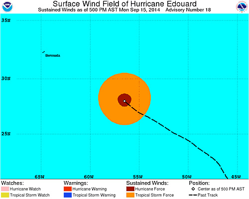
Whenever you’ve been skunked from a Tropical weather system even though it’s in your swell window, it’s probably because of a weak wind field. For example, Hurricane Bertha had barely any wind on her entire left side which meant no swell for us. Hurricane Edouward has the goods. With a symmetrical wind field like you see in the picture above and a large area of Hurricane force winds, he will shoot swell in all directions. On top of that his pressure is nice and low (currently at 963mb as I type this). Granted, storm path also has a lot to do with where the bulk of the swell will go too. The Eastern US is going to get perfect waves from this storm from the momentum of his movement so far. Nonetheless, due to that solid wind field, swell will make it to Puerto Rico.
What Kind of Surf to Expect:
Rincon: Hurricane Edouward is not predicted to pass 60 degrees West so NW swell is out of the picture. His movement will throw most of his swell everywhere but Rincon. The swell is mainly from the ENE to NE angle, but the period is forecast to be in the 12-14 second range. Rincon can expect to have some glassy knee to waist high surf Tomorrow, waist to chest waves with some head high sets mid-week with fading conditions through Friday.
Aguadilla/Isabela: You will be on fire! As early as Tuesday expect head high plus surf with glassy conditions every morning. The winds may stay light most of the day and glass off again at night. By the end of Tomorrow evening some spots might see some double overhead sets. The swell will remain stick around during the week. Smaller leftovers will probably linger through the weekend.
Arecibo, San Juan, and Fajardo: Pretty much the same forecast as Aguadilla/Isabela area except you will see the swell sooner. You will also get the brunt of the swell so a lot of places will be working!
Check the automated model forecast below using my custom viewer. It updates itself every model run to keep you up-to-date on the predicted swell. NOTE: NOAA’s server that hosts the images appears to be messed up at the moment. When the images are back online they will appear again automatically.
Today
NOAA WaveWatch III Wave Model:

Forecast Swell Period:

Forecast Winds:

Thu
NOAA WaveWatch III Wave Model:

Forecast Swell Period:

Forecast Winds:

Fri
NOAA WaveWatch III Wave Model:

Forecast Swell Period:

Forecast Winds:

Sat
NOAA WaveWatch III Wave Model:

Forecast Swell Period:

Forecast Winds:

Sun
NOAA WaveWatch III Wave Model:

Forecast Swell Period:

Forecast Winds:

Mon
NOAA WaveWatch III Wave Model:

Forecast Swell Period:

Forecast Winds:

Tue
NOAA WaveWatch III Wave Model:

Forecast Swell Period:

Forecast Winds:

Wed
NOAA WaveWatch III Wave Model:

Forecast Swell Period:

Forecast Winds:


