Rincon, Puerto Rico Surf Forecast – Sept 18, 2015

Watch the weather for possible surf.

Plenty of weather to watch for possible surf in Rincon.

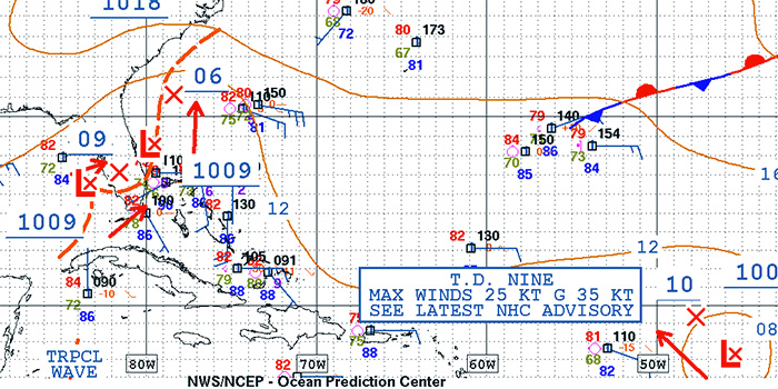
We have a lot of weather going on but nothing that screams surf just yet. First of all, Tropical Depressions Nine and Ten are meaningless storms that will serve no purpose in life. Forget about them. However, that tropical blob hanging around off the coast of the Florida might be our best bet. If it can develop we’ll get decent surf as long as it can whip out a little more to the east. All of the storms suffer from westerly and southwesterly shear so don’t expect any windfield on his west side. Any swell we get will be from it’s possible movement east along with pressure gradient and a possible front or high pressure that may move the storm. If we get enough weather behind that blob we could see a week’s worth of fun surf. That’s the best case scenario. The worst case scenario (and most likely) is that the blob just gets swept away from a week front that only climbs lattitude and goes to Cananda and we get the skunk. Only time will tell. Any new swell to show up should get here around mid-week next week.

Today

NOAA WaveWatch III Wave Model:

Wave Watch III from NOAA wave prediction model for surfing Puerto Rico.

Forecast Swell Period:

Forecast Winds:

Sun

NOAA WaveWatch III Wave Model:

Wave Watch III from NOAA wave prediction model for surfing Puerto Rico.

Forecast Swell Period:

Forecast Winds:

Mon

NOAA WaveWatch III Wave Model:

Wave Watch III from NOAA wave prediction model for surfing Puerto Rico.

Forecast Swell Period:

Forecast Winds:

Tue

NOAA WaveWatch III Wave Model:

Wave Watch III from NOAA wave prediction model for surfing Puerto Rico.

Forecast Swell Period:

Forecast Winds:

Wed

NOAA WaveWatch III Wave Model:

Wave Watch III from NOAA wave prediction model for surfing Puerto Rico.

Forecast Swell Period:

Forecast Winds:

Thu

NOAA WaveWatch III Wave Model:

Wave Watch III from NOAA wave prediction model for surfing Puerto Rico.

Forecast Swell Period:

Forecast Winds:

Fri

NOAA WaveWatch III Wave Model:

Wave Watch III from NOAA wave prediction model for surfing Puerto Rico.

Forecast Swell Period:

Forecast Winds:

Sat

NOAA WaveWatch III Wave Model:

Wave Watch III from NOAA wave prediction model for surfing Puerto Rico.

Forecast Swell Period:

Forecast Winds:

Atlantic Ocean Satellite Loop

Using Automated Forecast Tools:

Remember that no matter what a computer model tells you, what you see on the beach might be completely different. That's why i go take pictures of the beach every day. These tools help give an idea of what to expect, but weather prediction is not always exact especially the further out you try to forecast. Surf forecasting takes into account the general correlation between past weather data and resulting surf conditions. Another thing to keep in mind is the difference between actual swell height and the face height of the rideable wave it creates. For example. When the waves are forecast to have a 6ft swell at 13 seconds or higher with a NW angle we normally get waves that most people would call double over-head on sets. Swell angle is also important, especially for shorter period swell (9-11 seconds). For example 3ft at 11 seconds from the NW will make a bigger wave than 4ft at 9 seconds from the NE. Normally longer period swell (13+ seconds) will be more powerful and keep the surf size a little better even if the angle isn't a direct hit to Rincon. Generally any swell less than 9 seconds is super weak here in Rincon unless it has a lot of west in it. Also, most NE swell under 12 seconds is weak and mushy. 2ft at 8 seconds is generally small to flat. ENE swell will almost never make it into Rincon unless it was something like 10ft at 18 seconds from the ENE.