Rincon, Puerto Rico Surf Forecast – Mar 25, 2016

Puerto Rico Surf Forecast.

It’s not looking good – no surf for Rincon.

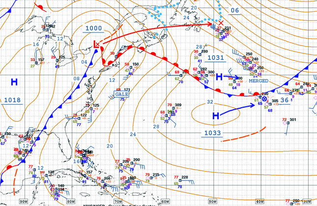
The forecast is simple – we will stay flat for the next 10 days. But I guess I owe it to everyone to at least explain why. Looking at the weather chart above, if all the of the H’s were L’s and all the L’s were H’s we would have the biggest and best swell of all time. Unfortunately, that’s the opposite of what we have now. All of the fetch over the Atlantic pushes waves away from Rincon, not towards it. Wind around a high pressure system spins clockwise and wind around low pressure systems spins counterclockwise. There is a weak front trying to push off the states that might make a waist high background swell at some point, but that is about it.

Where can you find waves?

Spain and Portugal will be on fire next week. Can’t go over there? If you’re spring break is starting to look broken, don’t worry. The north coast of the island should have a decent supply of wind swell the remainder of the month. Mornings can offer at least a semi-clean wave and there is enough coastline to avoid extreme crowds if you’re willing to surf a sloppier wave. Easterly wind swell limits your options though and you will need to find a spot that is very exposed to have any size in the surf.

Today

NOAA WaveWatch III Wave Model:

Wave Watch III from NOAA wave prediction model for surfing Puerto Rico.

Forecast Swell Period:

Forecast Winds:

Fri

NOAA WaveWatch III Wave Model:

Wave Watch III from NOAA wave prediction model for surfing Puerto Rico.

Forecast Swell Period:

Forecast Winds:

Sat

NOAA WaveWatch III Wave Model:

Wave Watch III from NOAA wave prediction model for surfing Puerto Rico.

Forecast Swell Period:

Forecast Winds:

Sun

NOAA WaveWatch III Wave Model:

Wave Watch III from NOAA wave prediction model for surfing Puerto Rico.

Forecast Swell Period:

Forecast Winds:

Mon

NOAA WaveWatch III Wave Model:

Wave Watch III from NOAA wave prediction model for surfing Puerto Rico.

Forecast Swell Period:

Forecast Winds:

Tue

NOAA WaveWatch III Wave Model:

Wave Watch III from NOAA wave prediction model for surfing Puerto Rico.

Forecast Swell Period:

Forecast Winds:

Wed

NOAA WaveWatch III Wave Model:

Wave Watch III from NOAA wave prediction model for surfing Puerto Rico.

Forecast Swell Period:

Forecast Winds:

Thu

NOAA WaveWatch III Wave Model:

Wave Watch III from NOAA wave prediction model for surfing Puerto Rico.

Forecast Swell Period:

Forecast Winds:

Atlantic Ocean Satellite Loop

Using Automated Forecast Tools:

Remember that no matter what a computer model tells you, what you see on the beach might be completely different. That's why i go take pictures of the beach every day. These tools help give an idea of what to expect, but weather prediction is not always exact especially the further out you try to forecast. Surf forecasting takes into account the general correlation between past weather data and resulting surf conditions. Another thing to keep in mind is the difference between actual swell height and the face height of the rideable wave it creates. For example. When the waves are forecast to have a 6ft swell at 13 seconds or higher with a NW angle we normally get waves that most people would call double over-head on sets. Swell angle is also important, especially for shorter period swell (9-11 seconds). For example 3ft at 11 seconds from the NW will make a bigger wave than 4ft at 9 seconds from the NE. Normally longer period swell (13+ seconds) will be more powerful and keep the surf size a little better even if the angle isn't a direct hit to Rincon. Generally any swell less than 9 seconds is super weak here in Rincon unless it has a lot of west in it. Also, most NE swell under 12 seconds is weak and mushy. 2ft at 8 seconds is generally small to flat. ENE swell will almost never make it into Rincon unless it was something like 10ft at 18 seconds from the ENE.