Rincon, Puerto Rico Surf Forecast – Sept 14, 2014
Get Ready to Surf! Hurricane Edouward Blows Up!
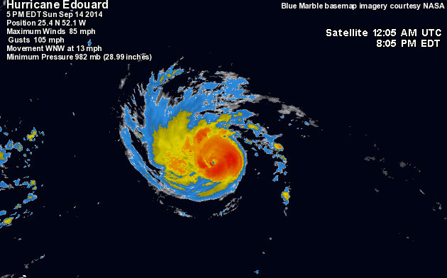
In an earlier post I was complaining about the strong windshear and dry air in the Northern Atlantic. Well this storm survived the gauntlet and found him self in a low shear and high ocean heat on the other side of the wind shear force field. The result – Hurricane Edouward may become the first (and possibly only) major hurricane of the 2014 Atlantic Season. This is a real Hurricane people. A solid wind-field, low pressure dropping by the minute, and nothing but open water around him. He will give some parts of Puerto Rico almost an entire week of waves.
What Kind of Surf to Expect:
Rincon: Hurricane Edouward is not predicted to pass 60 degrees West so NW swell is out of the picture. His movement will throw most of his swell everywhere but Rincon. The swell is mainly from the ENE to NE angle, but the period is forecast to be in the 12-14 second range. Rincon can expect to have some glassy waist to chest waves with some head high sets mid-week with fading conditions through Friday.
Aguadilla/Isabela: You will be on fire! As early as Tuesday expect head high plus surf with glassy conditions every morning. The winds may stay light most of the day and glass off again at night. The swell will pretty much rage through the week after that with some double overhead surf at some spots. Smaller leftovers will probably linger through the weekend.
Arecibo, San Juan, and Fajardo: Pretty much the same forecast as Aguadilla/Isabela area except you will see the swell sooner. You will also get the brunt of the swell so a lot of places will be working!
Check the automated model forecast below using my custom viewer. It updates itself every model run to keep you up-to-date on the predicted swell.
Today
NOAA WaveWatch III Wave Model:

Forecast Swell Period:

Forecast Winds:

Fri
NOAA WaveWatch III Wave Model:

Forecast Swell Period:

Forecast Winds:

Sat
NOAA WaveWatch III Wave Model:

Forecast Swell Period:

Forecast Winds:

Sun
NOAA WaveWatch III Wave Model:

Forecast Swell Period:

Forecast Winds:

Mon
NOAA WaveWatch III Wave Model:

Forecast Swell Period:

Forecast Winds:

Tue
NOAA WaveWatch III Wave Model:

Forecast Swell Period:

Forecast Winds:

Wed
NOAA WaveWatch III Wave Model:

Forecast Swell Period:

Forecast Winds:

Thu
NOAA WaveWatch III Wave Model:

Forecast Swell Period:

Forecast Winds:


