Rincon, Puerto Rico Surf Forecast – August 21, 2015
Are we all gonna die?!
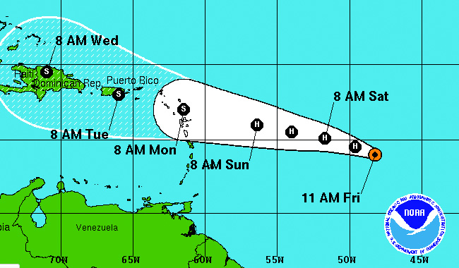
I certainly hope not. I do not believe this storm will cause as much damage as the sensational news reports would have us all believe. I started to see the current forecast track as a possibility a couple of NHC forecast updates prior – the storm would end up getting picked up north just enough to hit our little island straight across. As a rule of thumb everyone should prepare for the worst and hope for the best. Be prepared to be without water and power for at least three days and possibly a week if we get more than we bargained for.
What I think will actually happen:
The storm is picking up some strong winds, but it’s a tiny storm and it’s favorable conditions for strengthening will soon come to an end. Hurricane Danny will be sheared and dried up to a very weak tropical system by the time it gets close to our island. I think the forecast track will shift a little more north than it’s current route. I see a tropical blob quickly passing over San Juan, but covering most of the island with rain early next week for about one day. The forward speed is forecast to accelerate as it passes us and this is one scenario that has always remained for every forecast update from the NHC. The realistic damage that I foresee is some flash flooding in the Caguas area and the super drought stricken south end of the island. The wind won’t be too bad, but it doesn’t take much to knock the power out for a day or two. I think what a lot of people don’t realize is that many neighborhoods lose power at least twice a week for 4-8 hours at a time. Areas prone to losing power will probably lose power for a day or so regardless of what this storm does.
What about the surf?
As the storm approaches, the east coast and southeast corner of Puerto Rico will see some big ground swell. If you can time it right to get favorable winds before the destruction ensues you’ll be able to find some sick barrels at many of the hidden spots over there. The north side of the island will see some head high surf with crazy currents and sideshore winds. Rincon will probably get some waist high wind wobblers. If the storm can regenerate over the Bahamas we might get some kickback from the NW. Since the storm will always be moving away from Rincon, the chances of considerable surf are low. If this thing can blow up again off the coast of FL or NC then we can start to hope for bigger surf with south winds.
Today
NOAA WaveWatch III Wave Model:

Forecast Swell Period:

Forecast Winds:

Sat
NOAA WaveWatch III Wave Model:

Forecast Swell Period:

Forecast Winds:

Sun
NOAA WaveWatch III Wave Model:

Forecast Swell Period:

Forecast Winds:

Mon
NOAA WaveWatch III Wave Model:

Forecast Swell Period:

Forecast Winds:

Tue
NOAA WaveWatch III Wave Model:

Forecast Swell Period:

Forecast Winds:

Wed
NOAA WaveWatch III Wave Model:

Forecast Swell Period:

Forecast Winds:

Thu
NOAA WaveWatch III Wave Model:

Forecast Swell Period:

Forecast Winds:

Fri
NOAA WaveWatch III Wave Model:

Forecast Swell Period:

Forecast Winds:


