Rincon, Puerto Rico Surf Forecast – August 26, 2015
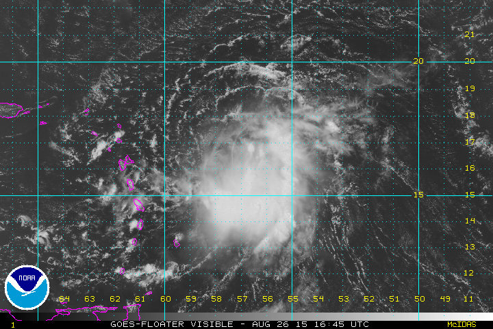
Tropical Storm Erika hits Puerto Rico tomorrow night! Ready?
Hurricane Danny was a tiny little thing that got sheared to pieces. It didn’t even rain in Rincon – not one single drop. It disintegrated prior to reaching the island though. Tropical Storm Erika is a bigger and more resilient weather system. I think the heavy shear and dry air will definitely kill it as a Tropical Cyclone, but I forecast more actual rain and wind with this storm. Be prepared for the worst and hope for the best.
Surf?
For most of the island, yes. The southeast and north coasts of the island should see more waves from this system than the tiny micro swell that came with Danny. The wind field is larger and has always made some easterly swell and has always had solid easterly movement. The southeast should see some head high waves and north side of the island will see some overhead surf. Bear in mind that the timing will mean everything. You’ll want to be there when the winds are just right and there’s enough swell. The window for that to happen will be close to when the weather will be the worst so be careful! When it all goes to crap the currents and wind will make the ocean a bad place to be. For the southeast, your window will be on the approach of the storm as the winds get pulled offshore up until approach. For the north coast of the island, your window will be just long enough after she passes to still have swell, south winds, and not victory at sea conditions (that’s going to be a very short window if at all). Here in Rincon will might see some wrap-around swell in the knee to waist high range when whatever is left of Erika passes us. After she passes us, if she can regenerate and get her act together over by the Bahamas we could see some fun WNW swell. I see it more as a possibility with this weather system than I did with Danny. I’ll try to have good coverage on this storm because I see more potential with it than I did with Danny (and we all saw what a disappointment he turned out to be).
Today
NOAA WaveWatch III Wave Model:

Forecast Swell Period:

Forecast Winds:

Sat
NOAA WaveWatch III Wave Model:

Forecast Swell Period:

Forecast Winds:

Sun
NOAA WaveWatch III Wave Model:

Forecast Swell Period:

Forecast Winds:

Mon
NOAA WaveWatch III Wave Model:

Forecast Swell Period:

Forecast Winds:

Tue
NOAA WaveWatch III Wave Model:

Forecast Swell Period:

Forecast Winds:

Wed
NOAA WaveWatch III Wave Model:

Forecast Swell Period:

Forecast Winds:

Thu
NOAA WaveWatch III Wave Model:

Forecast Swell Period:

Forecast Winds:

Fri
NOAA WaveWatch III Wave Model:

Forecast Swell Period:

Forecast Winds:


