Rincon, Puerto Rico Surf Forecast – Jan 5, 2017
Cold-front bombs out giving surf to Rincon, Puerto Rico.
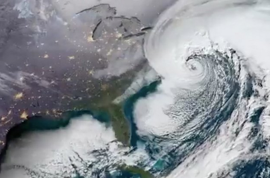
Now we’re talking! This storm is a beast and it rapidly intensified right in our swell window. Sorry for all the folks in the NE United States who are going to get rocked by this massive storm. I hope you’re alright when this is all done. Bombogenesis is actually a real thing and is associated with some of the biggest swells to hit PR and unfortunately the most winter destruction in the northern latitudes at the same time. This storm definitely “bombed out” big time and will give us the first big swell of 2018. Expect some perfect Tres Palmas this weekend and just about every other spot performing as it does in a classic winter swell. Due to what I’m seeing on the Bahamas buoys, I’m inclined to think we’ll see the swell show up a bit bigger than what the automated surf forecast systems are anticipating. We’re definitely going to see double overhead conditions and possibly bigger. DO NOT PADDLE OUT IF YOU DON’T KNOW WHAT YOU’RE DOING IN BIG WAVES! I really don’t want anyone to die surfing this storm. Please do not overestimate your abilities or underestimate the power of the ocean. As surfers we are always at the mercy of the elements. We are only in control of our own actions and nothing else. If the ocean wants to throw a 20ft clean-up set at you, it will and there’s nothing you can do to stop it. You can only control where you are when that happens. For many, sitting on the beach watching will be the safest place to be when that happens.
More reasonable surf should be on tap for the coming week and offer plenty of “normal” waves that will still pack a punch. As of right now we’ve already had a couple of days of surf from this weather system and it looks like another week of rideable waves will follow. Plenty of opportunities at several spots should be available in the coming week so there’s no need to crowd one break. Expect a little bit of size to drop off each day, but if the right pattern sticks, we could see another decent long period swell by the end of next week to keep everyone surfing through the first half of January. I guess after a very quiet December surf-wise, the earth is trying to catch back up. Be safe everyone! Have fun!
Today
NOAA WaveWatch III Wave Model:

Forecast Swell Period:

Forecast Winds:

Sat
NOAA WaveWatch III Wave Model:

Forecast Swell Period:

Forecast Winds:

Sun
NOAA WaveWatch III Wave Model:

Forecast Swell Period:

Forecast Winds:

Mon
NOAA WaveWatch III Wave Model:

Forecast Swell Period:

Forecast Winds:

Tue
NOAA WaveWatch III Wave Model:

Forecast Swell Period:

Forecast Winds:

Wed
NOAA WaveWatch III Wave Model:

Forecast Swell Period:

Forecast Winds:

Thu
NOAA WaveWatch III Wave Model:

Forecast Swell Period:

Forecast Winds:

Fri
NOAA WaveWatch III Wave Model:

Forecast Swell Period:

Forecast Winds:


