Rincon, Puerto Rico Surf Forecast – June 13, 2020
Active Weather in June – Small Surf for Rincon, Puerto Rico.
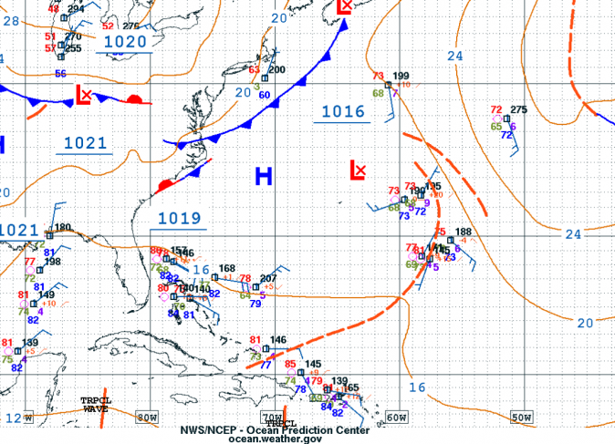
As you can see in the weather map above, the Atlantic still has a lot of activity going on. As a result some small scale surf should persist for the next couple of days. What happens beyond that has a lot of uncertainty. Most weather systems are beating expectations as far as surf is concerned. Historically we don’t get much surf action in June and we’ve seen a decent run of swell a couple weekends in a row. Will the pattern continue? I sure hope so! Will we know for sure? Not a chance. Unfortunately I would put a 3 day max on any reliable forecast right now. Tomorrow we should see the peak of this current small pulse with hopefully some more waist to chest high surf at exposed breaks in the morning. I anticipate that the swell will fade through the day and be very small on Monday. Tuesday will most likely go back to flat.
Unreliable speculation beyond 3 days:
I will be watching that open low out in the middle of the North Atlantic carefully. Any development of tropical characteristics will change the surf forecast drastically. Is it expected to develop tropical characteristics? No. It’s not. But it also wasn’t forecast to linger on for as long as it has. Persistent blobs of low pressure are often a point of interest this time of year since there is plenty of heat in the ocean right now. We also have some tropical waves that will be passing from Africa through the Caribbean over the next week as well. Those will be worth watching as well.
Get ready for Hurricane Season 2020!
The ocean is hot, the earth is angry. The second the wind shear starts dropping we’re going to see a lot of storms form this season. Make sure you’re prepared! Things could get complicated dealing with a storm along with the exiting increase of earthquakes and the current COVID-19 pandemic.
Today
NOAA WaveWatch III Wave Model:

Forecast Swell Period:

Forecast Winds:

Sun
NOAA WaveWatch III Wave Model:

Forecast Swell Period:

Forecast Winds:

Mon
NOAA WaveWatch III Wave Model:

Forecast Swell Period:

Forecast Winds:

Tue
NOAA WaveWatch III Wave Model:

Forecast Swell Period:

Forecast Winds:

Wed
NOAA WaveWatch III Wave Model:

Forecast Swell Period:

Forecast Winds:

Thu
NOAA WaveWatch III Wave Model:

Forecast Swell Period:

Forecast Winds:

Fri
NOAA WaveWatch III Wave Model:

Forecast Swell Period:

Forecast Winds:

Sat
NOAA WaveWatch III Wave Model:

Forecast Swell Period:

Forecast Winds:


