Rincon, Puerto Rico Surf Forecast – June 23, 2017
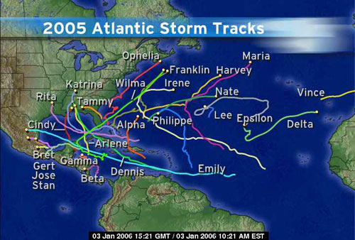
Will we have a season like 2005? Non-Stop Surf?
The short answer is simple – no. That year was a fluke and if it is part a longer cycle we may be waiting a really long time for another year like that. Nonetheless it gives us a reminder to expect the unexpected and realize that anything is possible. My personal assessment is that we will have a decent tropical surf season (officially called Hurricane Season). I’ve been doing a lot of reading on how solar maximum and minimum cycles affect global climate change. In my opinion it seems to be an element commonly overlooked but a powerful indicator to extreme weather. According to actual experts we can expect to see somewhat of a cooling pattern over the next few decades as opposed to continued global warming. I believe that because this is a gradual process, the ocean heat that has built up already will be able to interact with cooler upper atmospheric temps and lead to stronger storms in general – including tropical weather mostly in the form of more persistent sub-tropical and post-tropical storms. This means I hope to see a lot of tropical storms and hurricanes continue to dump swell after they go post-tropical.
So what about the actual surf forecast for Rincon?
There’s a reason I chose this weather post for the forecast. We’re quiet for surf. We might have some knee high surf lessons bumps for kids, but nothing noteworthy for the near term. That can change quickly if any of the ITCZ activity develops or bumps north. There’s no shortage of tropical waves moving off of Africa already so we can be on alert at any given moment, but sitting in front of satellite loops all day will be like watching water waiting for it to boil on the stove. It will feel like forever if you just sit there and stare at it. My advice is to be productive and find other ways to have fun as you patiently await the coming tropical surf.
Today
NOAA WaveWatch III Wave Model:

Forecast Swell Period:

Forecast Winds:

Sat
NOAA WaveWatch III Wave Model:

Forecast Swell Period:

Forecast Winds:

Sun
NOAA WaveWatch III Wave Model:

Forecast Swell Period:

Forecast Winds:

Mon
NOAA WaveWatch III Wave Model:

Forecast Swell Period:

Forecast Winds:

Tue
NOAA WaveWatch III Wave Model:

Forecast Swell Period:

Forecast Winds:

Wed
NOAA WaveWatch III Wave Model:

Forecast Swell Period:

Forecast Winds:

Thu
NOAA WaveWatch III Wave Model:

Forecast Swell Period:

Forecast Winds:

Fri
NOAA WaveWatch III Wave Model:

Forecast Swell Period:

Forecast Winds:


