Rincon, Puerto Rico Surf Forecast – Mar 27, 2017
Plenty more surf on the way for Rincon!
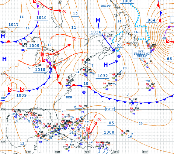
Wow what a busy weather map. That low that pulled up from the south was the only variable not picked up on by any of the model runs when I wrote the previous forecast. That whole setup was very rare for this time of year, but that low has been the gift that keeps on giving. The past 3 days have felt like a hurricane swell. Cranking NW swell and hard SW winds is always fun. There’s so much going on in the Atlantic right now that trying distinguish exactly how it will all contribute to the surf we see on the beach piece by piece is somewhat pointless. All you need to know is that the surf will continue to rage for the next 7 days. We shouldn’t get below waist to chest high at the main breaks and the mornings should be glassy. We might see a more onshore everywhere flow in the afternoons, but the mornings should always have a glassy option on at least one of the sides of Rincon. Wednesday looks like the scheduled arrival date for the next distinguishable pulse and we could easily see some overhead sets again with glassy conditions for the west facing spots. That pulse should linger through the weekend. I wouldn’t be surprised to see some long period swell creep in the mix as well from the far north storm, but none of the models are biting on that scenario yet – too much weather closer to the island. Have fun, stay safe, and show respect in the water.
Today
NOAA WaveWatch III Wave Model:

Forecast Swell Period:

Forecast Winds:

Sat
NOAA WaveWatch III Wave Model:

Forecast Swell Period:

Forecast Winds:

Sun
NOAA WaveWatch III Wave Model:

Forecast Swell Period:

Forecast Winds:

Mon
NOAA WaveWatch III Wave Model:

Forecast Swell Period:

Forecast Winds:

Tue
NOAA WaveWatch III Wave Model:

Forecast Swell Period:

Forecast Winds:

Wed
NOAA WaveWatch III Wave Model:

Forecast Swell Period:

Forecast Winds:

Thu
NOAA WaveWatch III Wave Model:

Forecast Swell Period:

Forecast Winds:

Fri
NOAA WaveWatch III Wave Model:

Forecast Swell Period:

Forecast Winds:


