Rincon Puerto Rico Surf Forecast – Mar 3, 2016
Surf is on the way! Get ready.
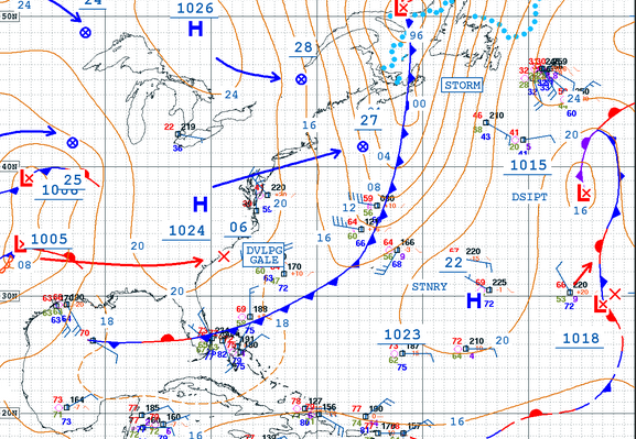
Well it seems that that our collective mind willing worked to get the storm out over the ocean sooner and stronger than previously forecast. Unfortunately I guess we all forgot to add a lower latitude push to our telepathic requests. The storm has in fact pushed out to sea and intensified, however it’s way up North by Nova Scotia. This means that the swell will need more time to get here. Arrival is still set for Monday. The period should be decent as we have hard north winds in our swell window with a decent fetch. The swinging of the trough can still put some NNW angle on it as well. Next week is going to rage! Unfortunately so will the winds so we might have some nastiness mid week.
Here’s how I see it playing out:
Friday: Pretty much flat, but maybe a knee high crumbler at the most exposed breaks.
Saturday: Some knee high cumblers for day 1 of the contest with super glassy conditions and no wind.
Sunday: Some waist high peelers for day 2 of the contest with glassy conditions and light wind. Hopefully we’ll see some chest high sets on occasion.
Monday: Swell shows up with a decent period and should be a couple feet overhead on sets and powerful early morning. By the end of the day we should see double overhead surf. The wind will pick up slightly but should be just the right amount of offshore for west facing spots to go off all day.
Tuesday: Swell sticks around with a bit more wind. The surf should stay in the 2-3ft overhead range through the day.
Wednesday: Massive windy swell in the double overhead range working only at super protected spots.
Thursday: Even more massive double to triple overhead gnarly wind swell with tucked away nooks and crannies working fairly well (i hope).
Today
NOAA WaveWatch III Wave Model:

Forecast Swell Period:

Forecast Winds:

Sat
NOAA WaveWatch III Wave Model:

Forecast Swell Period:

Forecast Winds:

Sun
NOAA WaveWatch III Wave Model:

Forecast Swell Period:

Forecast Winds:

Mon
NOAA WaveWatch III Wave Model:

Forecast Swell Period:

Forecast Winds:

Tue
NOAA WaveWatch III Wave Model:

Forecast Swell Period:

Forecast Winds:

Wed
NOAA WaveWatch III Wave Model:

Forecast Swell Period:

Forecast Winds:

Thu
NOAA WaveWatch III Wave Model:

Forecast Swell Period:

Forecast Winds:

Fri
NOAA WaveWatch III Wave Model:

Forecast Swell Period:

Forecast Winds:


