Rincon, Puerto Rico Surf Forecast – Oct 9, 2014
Surprise! The Tropics Turn on in October
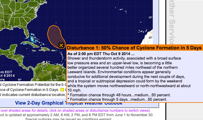
Whether or not this giant disturbance becomes a hurricane or not is kind of irrelevant. Unless it completely disintigrates it will make surf for Puerto Rico. The North coast of the island will get the brunt of the swell due to the angle and movement of the weather system. But it looks like Rincon will get enough of a wrap-around to stay fun all week into the weekend. I can’t believe that this giant beast chugged along through insane wind shear across the Atlantic only to park itself in our swell window which will actually be a considerably lighter shear environment for the storm.
Rincon: Expect waist to chest high NE swell and ENE wrap-around swell to come in from now through the weekend. Some pulses will be bigger as the weather system gets closer. Perfect longboard conditions will persist and some shortboard spots could be working as long as the wind plays nice. The winds are supposed to be pretty light for us pretty much the whole swell event.
Isabela/Aguadilla: You will be going off with plenty of head high surf at the usual prime spots. Some days will see some sets in the 2-4ft overhead range. The winds will be light, but they’re not currently forecast to blow hard South so you might have to look for wind blockage to get glassy conditions. You should have fun surf through the weekend into early next week.
Today
NOAA WaveWatch III Wave Model:

Forecast Swell Period:

Forecast Winds:

Sat
NOAA WaveWatch III Wave Model:

Forecast Swell Period:

Forecast Winds:

Sun
NOAA WaveWatch III Wave Model:

Forecast Swell Period:

Forecast Winds:

Mon
NOAA WaveWatch III Wave Model:

Forecast Swell Period:

Forecast Winds:

Tue
NOAA WaveWatch III Wave Model:

Forecast Swell Period:

Forecast Winds:

Wed
NOAA WaveWatch III Wave Model:

Forecast Swell Period:

Forecast Winds:

Thu
NOAA WaveWatch III Wave Model:

Forecast Swell Period:

Forecast Winds:

Fri
NOAA WaveWatch III Wave Model:

Forecast Swell Period:

Forecast Winds:


