Rincon, Puerto Rico Surf Forecast – Oct 12, 2014
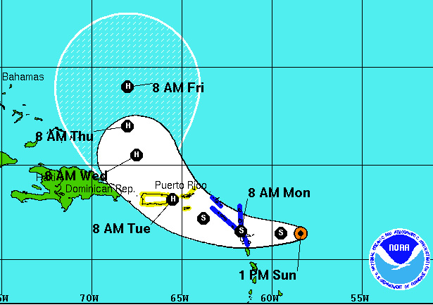
The Tropics Double Down as Tropical Storm Gonzalo Forms Today
All of this heat has to go somewhere. This summer has been brutally hot. My house is 91 degrees inside until 2am in the morning when it finally makes a quick drop down to more comfortable temps. This summer has been extremely hot and stagnant. This October has been extremely hot and stagnant. When the wind shear finally formed a bubble of weakness, it seems like tropical waves were ready to feed off all that heat! They have a banquet of heat! Tropical Storm Fay was happy to feed off that heat and now so is Tropical Storm Gonzalo.
Tropical Storm Fay will interact with a cold-front and go extra-tropical soon. All that commotion in the Northern Atlantic will throw some longer period NE swell at us. Tropical Storm Gonzalo is the double down. At first he will just serve to keep the winds offshore for North facing beaches, but he’s also forecast to explode just North of Puerto Rico and eventually be a wave-maker for the island as well. Hopefully he will give us some rain and cloud coverage as well. We could use the cool down.
Rincon: Look for the surf to remain waist high for the next couple of days building into Chest to Head High swell for Wednesday. After that, we could see waist to chest high surf persist into the weekend depending on how strong Gonzalo gets.
Isabela/Aguadilla: You should continue to stay chest high and build to a few feet overhead by mid-week. The Easterly movement of the storm on approach will give you the brunt of the early swell. After that, if the swell is predominately NE you will stay chest to head high through next weekend.
Patillas: You’re going to get rocked, but you should be going off as the storm approaches from now until Tuesday.
Today
NOAA WaveWatch III Wave Model:

Forecast Swell Period:

Forecast Winds:

Sat
NOAA WaveWatch III Wave Model:

Forecast Swell Period:

Forecast Winds:

Sun
NOAA WaveWatch III Wave Model:

Forecast Swell Period:

Forecast Winds:

Mon
NOAA WaveWatch III Wave Model:

Forecast Swell Period:

Forecast Winds:

Tue
NOAA WaveWatch III Wave Model:

Forecast Swell Period:

Forecast Winds:

Wed
NOAA WaveWatch III Wave Model:

Forecast Swell Period:

Forecast Winds:

Thu
NOAA WaveWatch III Wave Model:

Forecast Swell Period:

Forecast Winds:

Fri
NOAA WaveWatch III Wave Model:

Forecast Swell Period:

Forecast Winds:


