Rincon, Puerto Rico Surf Forecast – Sept 20, 2020
Hurricane Teddy Round Two – More Surf In Rincon!
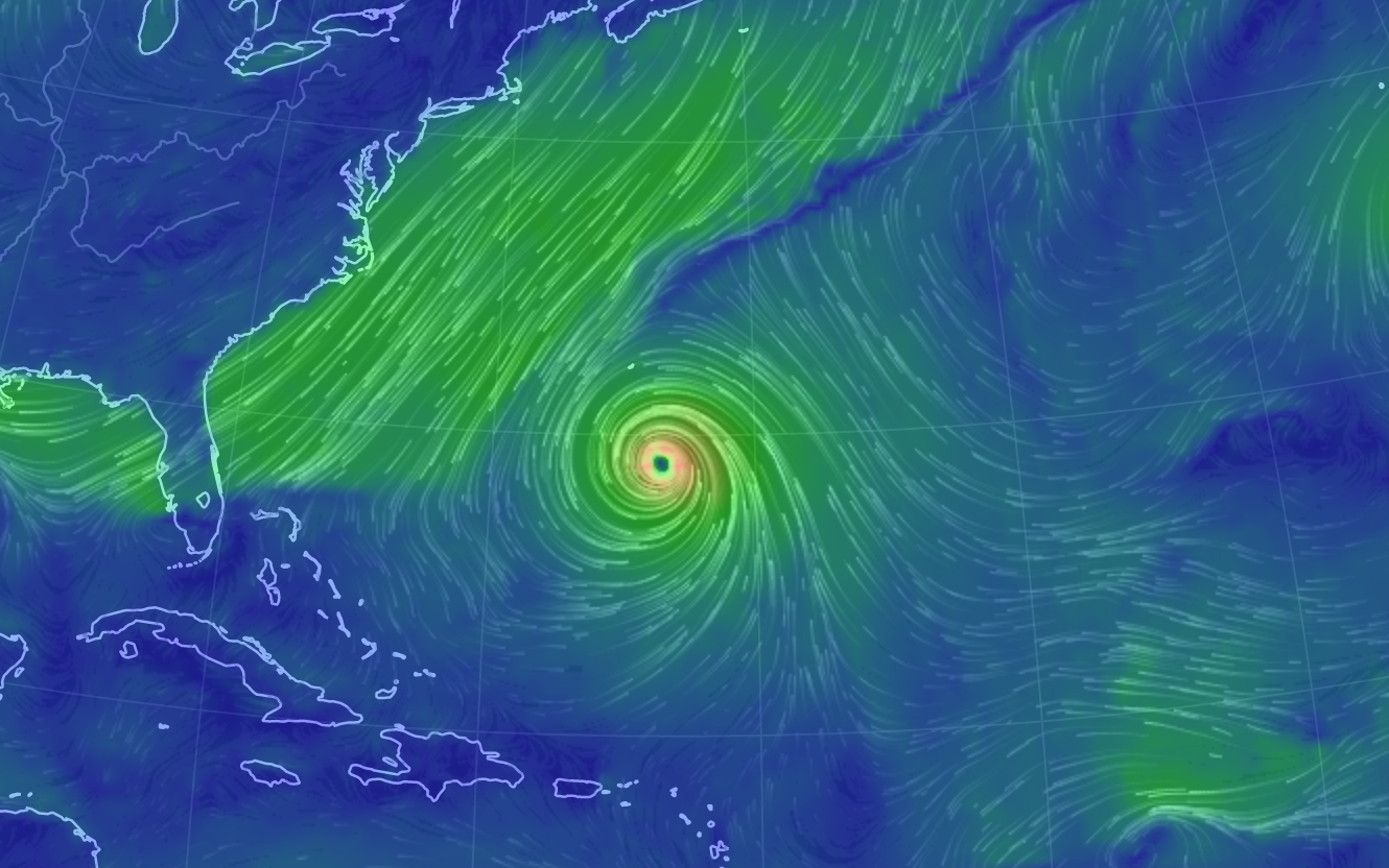
This coming week is going to see some very large swell. Most models are putting the biggest waves on Thursday. Expect double overhead and bigger surf with light winds on Thursday. Tow-in sessions will probably be in full effect. Tres will be on fire. Looking at the image above we can see how all this is possible. The hurricane itself is huge, yes, but notice the extremely long fetch of north winds along the extremely long frontal boundary that is swooping up Hurricane Teddy. As Teddy goes extratropical, that same fetch will span almost the entire North Atlantic and basically dump huge long period swell at us. This is a major swell event. Here’s how I see things playing out:
Monday will probably see the smallest surf of the week with chest to head high waves and bigger sets off and on. The wind will most likely be light in the morning and then pick up from the south.
Tuesday will most likely be a 2-4ft overhead day with the wind staying from the south. Expect double overhead sets to fill in with the incoming tide later in the day. North facing beaches should be on fire!
Wednesday will be another double overhead day and powerful. The wind might possibly just go completely slack for the first half of the day leaving every surf spot on the island full of swell. Pick your favorite nook and cranny spot as we could see some slight NNW angle hit.
Thursday is looking like the main event. Double to triple overhead surf with most main breaks maxed out. Big wave spots will be working their magic. Tucked away nook and cranny spots should be really good. The wind is supposed to stay light again for the first half of the day and then see a seabreeze everywhere in the afternoon.
Friday might drop off pretty fast leaving most spots 2-4ft overhead and glassy everywhere in Rincon for the morning session.
Saturday will see the continued decline with perfect chest to head high surf at most spots with exposed breaks still seeing some overhead sets in the morning.
Sunday will most likely be a smaller day with the entire island crammed into Rincon. It appears that it’s now a Sunday tradition for the entire island to assemble in Rincon and go to the beach.
Today
NOAA WaveWatch III Wave Model:

Forecast Swell Period:

Forecast Winds:

Sat
NOAA WaveWatch III Wave Model:

Forecast Swell Period:

Forecast Winds:

Sun
NOAA WaveWatch III Wave Model:

Forecast Swell Period:

Forecast Winds:

Mon
NOAA WaveWatch III Wave Model:

Forecast Swell Period:

Forecast Winds:

Tue
NOAA WaveWatch III Wave Model:

Forecast Swell Period:

Forecast Winds:

Wed
NOAA WaveWatch III Wave Model:

Forecast Swell Period:

Forecast Winds:

Thu
NOAA WaveWatch III Wave Model:

Forecast Swell Period:

Forecast Winds:

Fri
NOAA WaveWatch III Wave Model:

Forecast Swell Period:

Forecast Winds:


