Rincon, Puerto Rico Surf Forecast – Aug 26, 2019
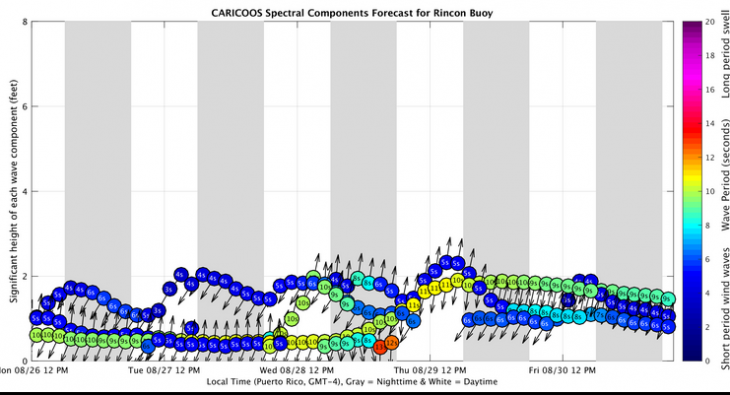
Small surf on the way for Rincon, Puerto Rico.
Remember surfing? Wasn’t it fun? We might get to do it again later this week. Even though there is a lot of focus on Tropical Storm Dorian right now (and we’ll get to that later), the surf will mostly be coming at us from Tropical Depression Six. Tropical Depression Six is a pretty poor excuse for a storm, but will cause enough commotion in the ocean to send us some waist to chest high waves on the the low tide for Thursday and Friday. If the timing plays out, Dorian will pull the winds south while the north swell from Six hits our beaches. The weather might be a bit rainy, but all north facing beaches could be really fun.
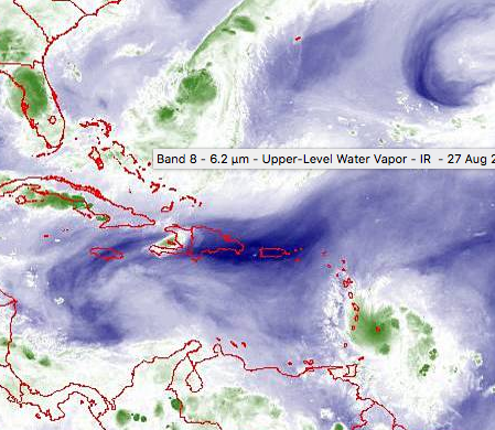
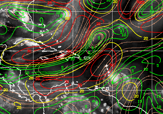
Taking a look at the satellite image above makes the combination of weather events clear. Tropical Depression Six has a lot of weather around it and is pushing out away from the states which will help push a small scale swell right at us. Tropical Storm Dorian looks to be on a path that will make the SE corner of PR go off, but a terrible path for sending swell at Rincon.
Tropical Storm Dorian Details
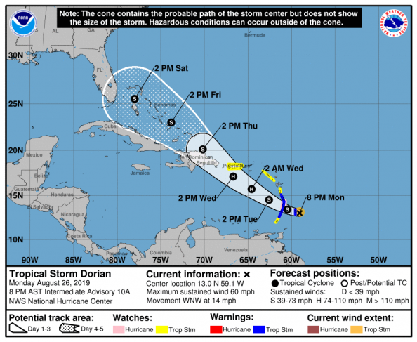 The good news is that Dorian will most likely not be a cause for major damage in Rincon, Puerto Rico. The bad news is that it won’t do much for surfing opportunities except for adding some grooming winds for whatever TD Six throws at us. Tropical weather can change very fast so please don’t let your guard down. Everyone should have preparations in order for the current hurricane season not just the current storm. I am a firm believer in good preparation. Now for a little more info on why I don’t currently see Dorian being a major problem for PR.
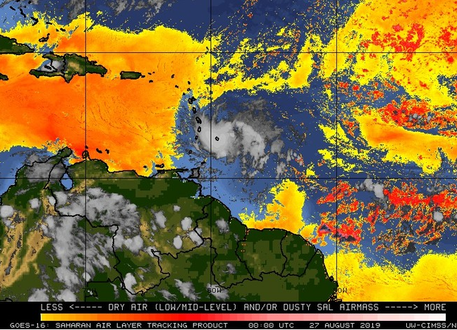
The Saharan Air Layer (Sahara Dust) and Dry Air – A constant impediment to rapid intensification
All of the official forecast discussion from the NHC has mentioned the profound effect of the SAL and Dry Air hindering the storm. The dry sandy air isn’t going anywhere. In my opinion, without all the dust and dry air, we would probably have another Maria on our hands. Stronger storms tend to be pulled further north which would lead to a path toward the north end of the forecast cone. In addition, the high heat and low shear would easily support rapid intensification and Dorian would have gone Cat 3 or Cat 5 by now. Perhaps in a parallel universe Dorian is a Maria, fortunately for us he doesn’t seem to be making it happen in our universe. DISCLAIMER: Still prepare and be cautious!
Wind Shear May Increase Along the Current Path
Weaker storms tend to follow the southern end of the forecast cone. If the wind shear picks up and doesn’t end up being as light as originally forecast, Dorian may end up very weak. This makes for a weaker storm further away from PR. For surf this may not be such a bad thing. The official forecast splits the difference in the low and high end intensity models and steering forecast. It was never going to give us much for surf other than a fun little waist high freak south wave on Wednesday. It still might, but at least it should keep the winds light offshore for the TD Six swell.
Be safe and have fun!
Pay constant attention to the advisories as they are issued and take whatever precautions are suggested by the authorities. If things change for the worse weather wise don’t be caught off guard. If all goes well we get to surf some little waves and no one gets hurt.
Today
NOAA WaveWatch III Wave Model:

Forecast Swell Period:

Forecast Winds:

Sun
NOAA WaveWatch III Wave Model:

Forecast Swell Period:

Forecast Winds:

Mon
NOAA WaveWatch III Wave Model:

Forecast Swell Period:

Forecast Winds:

Tue
NOAA WaveWatch III Wave Model:

Forecast Swell Period:

Forecast Winds:

Wed
NOAA WaveWatch III Wave Model:

Forecast Swell Period:

Forecast Winds:

Thu
NOAA WaveWatch III Wave Model:

Forecast Swell Period:

Forecast Winds:

Fri
NOAA WaveWatch III Wave Model:

Forecast Swell Period:

Forecast Winds:

Sat
NOAA WaveWatch III Wave Model:

Forecast Swell Period:

Forecast Winds:


