Rincon, Puerto Rico Surf Forecast – Aug 31, 2018
Possible Tropical Swell on the way for Surfing Puerto Rico.
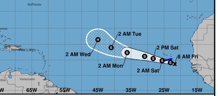
Though not officially a named storm yet, Possible Tropical Depression Six is getting organized off the coast of Africa and already bringing some heavy weather to the outer islands off the coast. It looks like the storm is bound to continue in it’s organization and strength. Whether or not this system becomes a wave-maker will depend on the route it takes near the end of next week and how far west it is able to move. As previously stated, I am not happy with the steering currents I’m seeing in general this hurricane season. Ideally this storm would be far enough north of Puerto Rico on its approach to not be a safety issue. In addition, if the storm tracks enough north to pull the winds south and travels enough far enough west, we would see a several day run of swell with offshore winds at the most exposed breaks. The steering currents are tending to favor a lower latitude path across the Atlantic which means the possible collision of the storm with our island or a storm that passes underneath us. Either scenario we get no surf and possible damage. We want this storm to climb latitude.
Where did our wind shear force field go?
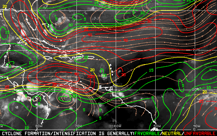 The easiest way to explain the map above is that the green areas favor tropical development, the yellow is marginal, and red prevents and inhibits formation/growth. We had a solid barrier of red in front of this storm all week, but now it’s as if the ocean is giving it a free pass. If the steering currents keep it in low shear, we might end up with a powerful storm by next weekend. I hope not.
What do I actually think will happen?
My opinion is that this storm will track north into the shear and disipate/die long before it reaches Puerto Rico and there is nothing to worry about. Also we will probably get no swell from it. Be on the lookout for early cold-fronts instead. We stay flat for the foreseeable future. Why all the discussion above then? It’s about stating the possibilities regardless of what I think will happen. Also my opinion is just that – an opinion, not fact. I am not always right.
Today
NOAA WaveWatch III Wave Model:

Forecast Swell Period:

Forecast Winds:

Sat
NOAA WaveWatch III Wave Model:

Forecast Swell Period:

Forecast Winds:

Sun
NOAA WaveWatch III Wave Model:

Forecast Swell Period:

Forecast Winds:

Mon
NOAA WaveWatch III Wave Model:

Forecast Swell Period:

Forecast Winds:

Tue
NOAA WaveWatch III Wave Model:

Forecast Swell Period:

Forecast Winds:

Wed
NOAA WaveWatch III Wave Model:

Forecast Swell Period:

Forecast Winds:

Thu
NOAA WaveWatch III Wave Model:

Forecast Swell Period:

Forecast Winds:

Fri
NOAA WaveWatch III Wave Model:

Forecast Swell Period:

Forecast Winds:


