Rincon, Puerto Rico Surf Forecast – Feb 26, 2018
Another round of long period swell to surf in Rincon, Puerto Rico.
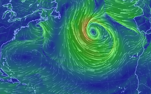
That massive storm in the middle of the Atlantic is impressive! It appears that a very strong long period swell will be spread across the entire North Atlantic by the end of the week. After an extremely windy, rainy, and weak wind-swell laden February, March is forecast to start off with a bang! Though Thursday, March 1st is the official arrival date of the new swell, some of the more reliable models are calling for the front-runners to hit by Wednesday evening. Monday, Tuesday, and Wednesday morning will mostly be just small scale wind-waves so I imagine everyone will be eagerly awaiting the next swell. Getting in on the early pulse without a crowd seems unlikely. However, the winds “might” calm down a bit and open up more opportunities for other Rincon spots during the coming swell event. This is going to be the key to crowd control in Rincon. All of February was pretty much unsurfable for the north facing beaches of Rincon. If that side can get clean again in the mornings, a lot more spots will be available and help to mitigate the heavy crowds. This has been a very crowded season so far and the weather pattern hasn’t been helping matters. Expect Thursday and Friday to have overhead surf with powerful long lines. The swell is coming from very far away so I wouldn’t be surprised if there was a decent amount of time in between sets. Patience and timing will be key.
Another swell on the horizon.
The long range models are putting a major storm right off the coast of the US towards the end of the forecast period with a possible long-period NW swell to follow. Though I really want to see this materialize, I am hesitant to jump on board with this scenario. High pressure has taken center stage so much lately. Unless the blocking high can be forced out of the way for a small amount of time, the storm will most likely have to go up and over like every other storm. There would still be the possibility for another open ocean NE long-period swell from the same weather system – that would be the scenario most likely to happen. In this case, the next pulse would show up about a week from now which would be consistent with the current pattern. The argument for the NW swell panning out is that the current and past weather pattern is somewhat uncharacteristic for this time of year and the earth might try to play catch-up with a late season dip and shift in the jetstream. We should have a better idea of what is going to happen later in the week.
Today
NOAA WaveWatch III Wave Model:

Forecast Swell Period:

Forecast Winds:

Thu
NOAA WaveWatch III Wave Model:

Forecast Swell Period:

Forecast Winds:

Fri
NOAA WaveWatch III Wave Model:

Forecast Swell Period:

Forecast Winds:

Sat
NOAA WaveWatch III Wave Model:

Forecast Swell Period:

Forecast Winds:

Sun
NOAA WaveWatch III Wave Model:

Forecast Swell Period:

Forecast Winds:

Mon
NOAA WaveWatch III Wave Model:

Forecast Swell Period:

Forecast Winds:

Tue
NOAA WaveWatch III Wave Model:

Forecast Swell Period:

Forecast Winds:

Wed
NOAA WaveWatch III Wave Model:

Forecast Swell Period:

Forecast Winds:


