Rincon, Puerto Rico Surf Forecast – Jan 20, 2017
What a beautiful storm – get ready to surf!
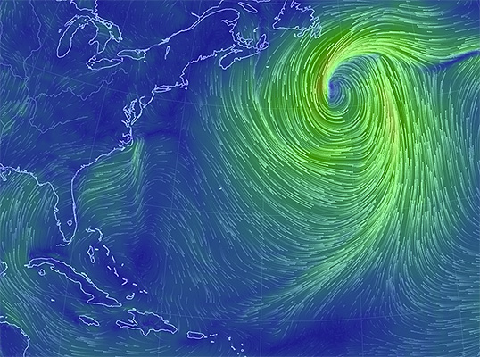
What you see above is a graphic representation generated from live wind data as of the time of this post. Notice how large and symmetrical that winter storm is? The last time we had a storm look like that setup in the same location was in November and we had an amazing swell. We should have a 4 day stretch of swell from this beast. Saturday and Sunday will see NNW to N swell and Monday and Tuesday will see NNE to NE swell with a long period. But that’s not all! There’s a double down! We have another powerful storm sweeping the states as we speak. This means that when the long period NNE kickback swell arrives from storm number one, storm number two will be pulling the winds hard offshore on it’s approach. Then as the swell from storm number one fades, the new NW swell from storm number two will fill in. Storm number two might also offer a 4 day stretch of swell also. This is basically the perfect setup.
How big will it get?
The size should stay in the head high to a couple feet overhead range, but I’m not ruling out some double overhead moments at peak times when the tide is just right and swell is hitting at just the right angle. We shouldn’t have the nonstop current battles that we had with the last major swell event so that should be good.
SAFETY:
Just because we’re not anticipating the swell to be massive doesn’t mean that there will be no risk. This will still be a powerful run of swell and the ocean always deserves respect. Be careful, be smart, don’t take unnecessary risks, and don’t just assume that nothing bad could possibly ever happen. Make sure you have a good leash in decent condition and that the leash string is tied properly and also in good condition. Boards will break on this swell and so will leashes. If it happens to you are you a good enough swimmer to make it back to shore? If not, then don’t paddle out.
Today
NOAA WaveWatch III Wave Model:

Forecast Swell Period:

Forecast Winds:

Sat
NOAA WaveWatch III Wave Model:

Forecast Swell Period:

Forecast Winds:

Sun
NOAA WaveWatch III Wave Model:

Forecast Swell Period:

Forecast Winds:

Mon
NOAA WaveWatch III Wave Model:

Forecast Swell Period:

Forecast Winds:

Tue
NOAA WaveWatch III Wave Model:

Forecast Swell Period:

Forecast Winds:

Wed
NOAA WaveWatch III Wave Model:

Forecast Swell Period:

Forecast Winds:

Thu
NOAA WaveWatch III Wave Model:

Forecast Swell Period:

Forecast Winds:

Fri
NOAA WaveWatch III Wave Model:

Forecast Swell Period:

Forecast Winds:


