Rincon Puerto Rico Surf Forecast – Jan 23, 2016
Classic NW cold front swell for Puerto Rico.
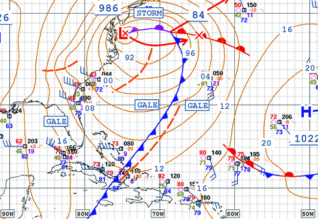
I am really liking this cold front! Plenty of fetch, low enough latitude, trough whipping out just right. Granted there isn’t a super strong high pressure behind the system, but look at all the gale force winds around it – it doesn’t need the turbo charger because it’s got plenty of power at stock. The oldschoolers here have told me in the past that before the internet and hi-res satellite imagery they just knew that if the winds blew south before a winter storm for 1 day the swell would be pretty decent. 2 days of south winds and the swell would be great! 3 or 4 days and you would have epic conditions. If the current forecast sticks we’ll have a great swell! I think this swell event is going to bigger and better than most people realize. The swell angle will have a lot west in it which makes for bigger and better conditions than one would think just looking at the swell height and period.
Sunday – Look for waist to chest high swell to persist in the morning and fade out into the early afternoon. Some of the front runners of the new swell might show up before dark with some head high sets.
Monday – Building NW swell that should reach double overhead by night time with light offshores for west facing beaches.
Tuesday – Double overhead and bigger all day with hard offshore winds at west facing beaches.
Wednesday – Head high with bigger sets and well groomed glassy conditions in the morning at west facing beaches.
Thursday – Chest high glass at all Rincon breaks in the morning.
Friday – Small surf lessons conditions at all Rincon breaks with glassy conditions.
Today
NOAA WaveWatch III Wave Model:

Forecast Swell Period:

Forecast Winds:

Sat
NOAA WaveWatch III Wave Model:

Forecast Swell Period:

Forecast Winds:

Sun
NOAA WaveWatch III Wave Model:

Forecast Swell Period:

Forecast Winds:

Mon
NOAA WaveWatch III Wave Model:

Forecast Swell Period:

Forecast Winds:

Tue
NOAA WaveWatch III Wave Model:

Forecast Swell Period:

Forecast Winds:

Wed
NOAA WaveWatch III Wave Model:

Forecast Swell Period:

Forecast Winds:

Thu
NOAA WaveWatch III Wave Model:

Forecast Swell Period:

Forecast Winds:

Fri
NOAA WaveWatch III Wave Model:

Forecast Swell Period:

Forecast Winds:


