Rincon, Puerto Rico Surf Forecast – July 29, 2020
PR getting windy, but no surf for Rincon yet.
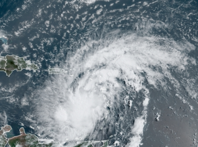
Potential Tropical Depression Nine will go down in history as the most significant tropical storm that was never an actual tropical storm. It’s still technically an open tropical wave with a broad circulation. It is creating more weather than some smaller Category 1 Hurricanes that have existed so it being a “Potential” depression is just a technical designation. This this is still an impressive weather system with some very real dangerous weather. Unfortunately, the new path means that we get all the bad weather and none of the waves. I am bummed about this. At least we have the sand monster from Africa to thank for throwing heaps of dry/sandy air all over this thing and keeping it from becoming another Maria. Honestly, without the sands all around it, we would have been in a very bad spot. At any given moment the weather system could finally develop a closed center and be a named storm officially so this isn’t over yet – not by a long shot. A stronger storm would be pulled on a more northward track. Either way, get ready for a couple of days of nasty weather and maybe some waist to chest high surf for the weekend.
BE SAFE!
We’re already in the middle of a medical crisis so please be extra careful. A simple rainstorm knocked a few trees down in some places. I can only imagine what a major storm would do right now. Please be prepared and don’t take unnecessary risks.
The south side of the island.
Yes, south spots should be firing while the winds are still north but currents could be a bit intense. There isn’t much on the south side of the storm so dead winds might persist after the passing of the storm allowing for some clean up days with groundswell as well. The south has been working exceptionally well lately due to the now common occurrence of passing tropical waves just about every 2-3 days.
Today
NOAA WaveWatch III Wave Model:

Forecast Swell Period:

Forecast Winds:

Sat
NOAA WaveWatch III Wave Model:

Forecast Swell Period:

Forecast Winds:

Sun
NOAA WaveWatch III Wave Model:

Forecast Swell Period:

Forecast Winds:

Mon
NOAA WaveWatch III Wave Model:

Forecast Swell Period:

Forecast Winds:

Tue
NOAA WaveWatch III Wave Model:

Forecast Swell Period:

Forecast Winds:

Wed
NOAA WaveWatch III Wave Model:

Forecast Swell Period:

Forecast Winds:

Thu
NOAA WaveWatch III Wave Model:

Forecast Swell Period:

Forecast Winds:

Fri
NOAA WaveWatch III Wave Model:

Forecast Swell Period:

Forecast Winds:


