Rincon, Puerto Rico Surf Forecast – Mar 26, 2018

Major Swell Event for Surfing Rincon, Puerto Rico.

Major Swell Event for Surfing Rincon, Puerto Rico.

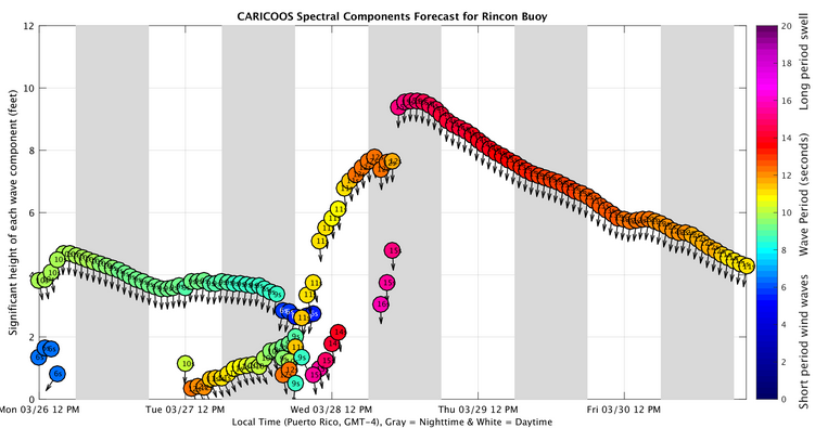
Get ready folks, the waves are going to get big again. The weather has been pretty active and we’re finally seeing some lower latitude storms pull off the states. The current system gave a decent dip/whip down and is currently amplifying just enough to give us a decent swell. Get ready for some more Tres Palmas action. This swell won’t be as massive as the swell of the season, but don’t underestimate it either. The period will be longest on Thursday and Friday as well as the swell height. Most people have the most fun on days with only 2-4ft of groundswell. So if you’re thinking 8ft at 15 seconds isn’t very big you’re going to be humbled pretty fast when you get to the beach. Use a good leash, inspect your equipment, and STAY SAFE! Tomorrow will probably stay around waist to chest high. Wednesday will start off around head high and build throughout the day into the double overhead range. Thursday will be double overhead and bigger. Friday will be close to double overhead. Saturday is looking more like a head high to a couple of feet overhead day and Sunday the waist to chest high leftovers. I really don’t see why we won’t have another swell event similar to this one next week around the same time as well. Another storm is sweeping across the states currently.

Today

NOAA WaveWatch III Wave Model:

Wave Watch III from NOAA wave prediction model for surfing Puerto Rico.

Forecast Swell Period:

Forecast Winds:

Sat

NOAA WaveWatch III Wave Model:

Wave Watch III from NOAA wave prediction model for surfing Puerto Rico.

Forecast Swell Period:

Forecast Winds:

Sun

NOAA WaveWatch III Wave Model:

Wave Watch III from NOAA wave prediction model for surfing Puerto Rico.

Forecast Swell Period:

Forecast Winds:

Mon

NOAA WaveWatch III Wave Model:

Wave Watch III from NOAA wave prediction model for surfing Puerto Rico.

Forecast Swell Period:

Forecast Winds:

Tue

NOAA WaveWatch III Wave Model:

Wave Watch III from NOAA wave prediction model for surfing Puerto Rico.

Forecast Swell Period:

Forecast Winds:

Wed

NOAA WaveWatch III Wave Model:

Wave Watch III from NOAA wave prediction model for surfing Puerto Rico.

Forecast Swell Period:

Forecast Winds:

Thu

NOAA WaveWatch III Wave Model:

Wave Watch III from NOAA wave prediction model for surfing Puerto Rico.

Forecast Swell Period:

Forecast Winds:

Fri

NOAA WaveWatch III Wave Model:

Wave Watch III from NOAA wave prediction model for surfing Puerto Rico.

Forecast Swell Period:

Forecast Winds:

Atlantic Ocean Satellite Loop

Using Automated Forecast Tools:

Remember that no matter what a computer model tells you, what you see on the beach might be completely different. That's why i go take pictures of the beach every day. These tools help give an idea of what to expect, but weather prediction is not always exact especially the further out you try to forecast. Surf forecasting takes into account the general correlation between past weather data and resulting surf conditions. Another thing to keep in mind is the difference between actual swell height and the face height of the rideable wave it creates. For example. When the waves are forecast to have a 6ft swell at 13 seconds or higher with a NW angle we normally get waves that most people would call double over-head on sets. Swell angle is also important, especially for shorter period swell (9-11 seconds). For example 3ft at 11 seconds from the NW will make a bigger wave than 4ft at 9 seconds from the NE. Normally longer period swell (13+ seconds) will be more powerful and keep the surf size a little better even if the angle isn't a direct hit to Rincon. Generally any swell less than 9 seconds is super weak here in Rincon unless it has a lot of west in it. Also, most NE swell under 12 seconds is weak and mushy. 2ft at 8 seconds is generally small to flat. ENE swell will almost never make it into Rincon unless it was something like 10ft at 18 seconds from the ENE.