Rincon, Puerto Rico Surf Forecast – May 13, 2018
Small to flat surf in Rincon for a long time to come.
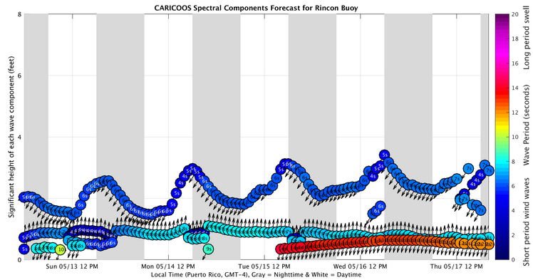
If you have found something else you like doing in Rincon while there is no waves, you’ll probably get pretty good at it. We stay small to flat for a long time. At this point, the only surf we’ll get is from Tropical Systems, and I am NOT looking forward to any future Tropical Systems. If you need to surf, the current flow of weather has been keeping the Southeast Corner of Puerto Rico surf-able. Jobos is also going to be rideable this coming week and from time to time when the wind swell picks up. The blips on the graph of the headline image are going to be the times where the wind chop should pick up. It will be small, windy, and complete garbage. If you are desperate, it won’t matter and you’ll go out there anyways.
My thoughts on the coming hurricane season for 2018.
I hope I’m wrong. I hope I have no idea what I’m talking about and that I’m just completely wrong. I see a very active hurricane season this season. We’re still recovering from last year’s season and this next season looks to get an early start. The ITCZ is VERY active. Open waves never stopped shooting off Africa. Random mid-level lows and surface troughs have been persisting around the Caribbean and Atlantic. The Caribbean and Adjacent Atlantic waters are already hot enough to support Tropical Cyclone formation. The ONE element hindering tropical development is upper level wind flow. That is the only non-conducive element in the current weather situation pertaining to Tropical Storm and Hurricane formation near us. Fortunately, favorable upper level winds are crucial in the early stages of a developing system. As long as they remain unfavorable, is very unlikely a dangerous system can form. However, it’s only a matter of time before windows of opportunity within the upper level wind flow will start to appear. The steer patterns for Atlantic and Caribbean weather seem very similar to last year as well. Be prepared.
Today
NOAA WaveWatch III Wave Model:

Forecast Swell Period:

Forecast Winds:

Sat
NOAA WaveWatch III Wave Model:

Forecast Swell Period:

Forecast Winds:

Sun
NOAA WaveWatch III Wave Model:

Forecast Swell Period:

Forecast Winds:

Mon
NOAA WaveWatch III Wave Model:

Forecast Swell Period:

Forecast Winds:

Tue
NOAA WaveWatch III Wave Model:

Forecast Swell Period:

Forecast Winds:

Wed
NOAA WaveWatch III Wave Model:

Forecast Swell Period:

Forecast Winds:

Thu
NOAA WaveWatch III Wave Model:

Forecast Swell Period:

Forecast Winds:

Fri
NOAA WaveWatch III Wave Model:

Forecast Swell Period:

Forecast Winds:


