Rincon, Puerto Rico Surf Forecast – Nov 10, 2019
Cold front swell and fun surf in Rincon, PR.
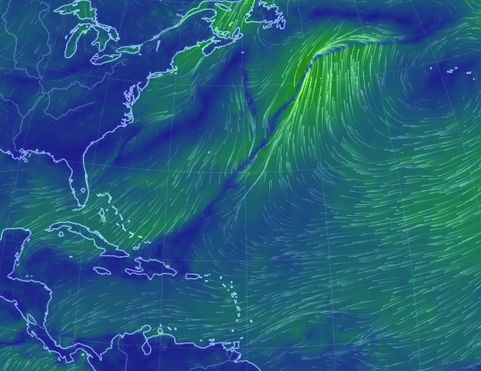
This next front isn’t the biggest storm, but the swoop out into the Atlantic and decent NE fetch on the back side of it will give us waves for the work week. Don’t expect anything huge, but we should have some persistent swell and fun conditions over the next few days. The more powerful front is forecast to avoid our swell window all together and make europe continue to fire. Let’s hope that isn’t the theme of this season. We’ve had a fair mix of early fronts, late tropical systems, and hybrid storms so I’m inclined to think variety will be the theme of this season with a few decent runs of classic cold-front swell. Here’s how I see the next 5 days playing out:
Monday will be the biggest with some 2-3ft overhead sets by sundown. I wouldn’t be surprised by a late arrival as the NW swell is on the North Atlantic buoy but completely absent from all the other buoys. This often happens when the NW is generated too far east off the US. We might end up with more of a N to NNE angle in what actually shows up.
Tuesday will most likely be similar to Monday mid-day but the swell will have a little less power and a little longer wait in between sets. We’re still talking head high at the more exposed breaks though and the winds should be fairly light for the first half of the day. Lighter winds means more breaks to surf without a crowd.
Wednesday NE leftovers in the chest high range with light winds will stick around almost the entire day.
Thursday old swell completely dies out while a background pulse from another weather system shows up. At this point we’ll have a better idea of any possible long period swell that might be generated from the Far North Atlantic or at least another weak front with a smaller scale NW pulse.
Friday could see a bump up in the surf with some overhead sets at exposed breaks.
As always check back through the week as I will update if anything changes. As stated in the breakdown, a possible long period swell event may be on the horizon beyond 10 days from a possible large storm in the far North Atlantic.
Today
NOAA WaveWatch III Wave Model:

Forecast Swell Period:

Forecast Winds:

Thu
NOAA WaveWatch III Wave Model:

Forecast Swell Period:

Forecast Winds:

Fri
NOAA WaveWatch III Wave Model:

Forecast Swell Period:

Forecast Winds:

Sat
NOAA WaveWatch III Wave Model:

Forecast Swell Period:

Forecast Winds:

Sun
NOAA WaveWatch III Wave Model:

Forecast Swell Period:

Forecast Winds:

Mon
NOAA WaveWatch III Wave Model:

Forecast Swell Period:

Forecast Winds:

Tue
NOAA WaveWatch III Wave Model:

Forecast Swell Period:

Forecast Winds:

Wed
NOAA WaveWatch III Wave Model:

Forecast Swell Period:

Forecast Winds:


