Rincon, Puerto Rico Surf Report – Feb 1, 2018

Flatspell on the horizon for surfing Rincon, Puerto Rico.

Flatspell on the horizon for surfing Rincon, Puerto Rico.

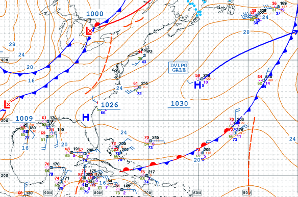
Here’s the good news. The ocean has one last pulse to throw at us from weather we were seeing all week. I expect that the initial NW angled front-runners will show up by this evening. Friday morning should be really fun and around head-high with some sets a couple of feet overhead. Saturday will drop a little bit and slowly fade out. After that we have a bit of a flatspell on tap from what is happening in the ocean right now. More exposed spots on the north side of the island should still see some ride-able surf with windy conditions in the chest high range. I’ll try to update again on Sunday to have a better look at how the next week is going to go. As of now, it’s looking like flat. Models are calling for the latest cold-front to be blocked by high pressure and go up and over our swell window. I’m tired of this happening. If the jetstream can dip we could see a classic cold-front swell. It’s the time of year to see that happen so I hope this cold-front defies it’s current forecast. If you’re thinking of coming to Rincon to learn how to surf then you will actually be very happy to be here. The waves will still be good for surf lessons here in Rincon. Thrill-seekers will have to go elsewhere.

Today

NOAA WaveWatch III Wave Model:

Wave Watch III from NOAA wave prediction model for surfing Puerto Rico.

Forecast Swell Period:

Forecast Winds:

Thu

NOAA WaveWatch III Wave Model:

Wave Watch III from NOAA wave prediction model for surfing Puerto Rico.

Forecast Swell Period:

Forecast Winds:

Fri

NOAA WaveWatch III Wave Model:

Wave Watch III from NOAA wave prediction model for surfing Puerto Rico.

Forecast Swell Period:

Forecast Winds:

Sat

NOAA WaveWatch III Wave Model:

Wave Watch III from NOAA wave prediction model for surfing Puerto Rico.

Forecast Swell Period:

Forecast Winds:

Sun

NOAA WaveWatch III Wave Model:

Wave Watch III from NOAA wave prediction model for surfing Puerto Rico.

Forecast Swell Period:

Forecast Winds:

Mon

NOAA WaveWatch III Wave Model:

Wave Watch III from NOAA wave prediction model for surfing Puerto Rico.

Forecast Swell Period:

Forecast Winds:

Tue

NOAA WaveWatch III Wave Model:

Wave Watch III from NOAA wave prediction model for surfing Puerto Rico.

Forecast Swell Period:

Forecast Winds:

Wed

NOAA WaveWatch III Wave Model:

Wave Watch III from NOAA wave prediction model for surfing Puerto Rico.

Forecast Swell Period:

Forecast Winds:

National Hurricane Forecast Center
Atlantic Ocean Satellite Loop

Using Automated Forecast Tools:

Remember that no matter what a computer model tells you, what you see on the beach might be completely different. That's why i go take pictures of the beach every day. These tools help give an idea of what to expect, but weather prediction is not always exact especially the further out you try to forecast. Surf forecasting takes into account the general correlation between past weather data and resulting surf conditions. Another thing to keep in mind is the difference between actual swell height and the face height of the rideable wave it creates. For example. When the waves are forecast to have a 6ft swell at 13 seconds or higher with a NW angle we normally get waves that most people would call double over-head on sets. Swell angle is also important, especially for shorter period swell (9-11 seconds). For example 3ft at 11 seconds from the NW will make a bigger wave than 4ft at 9 seconds from the NE. Normally longer period swell (13+ seconds) will be more powerful and keep the surf size a little better even if the angle isn't a direct hit to Rincon. Generally any swell less than 9 seconds is super weak here in Rincon unless it has a lot of west in it. Also, most NE swell under 12 seconds is weak and mushy. 2ft at 8 seconds is generally small to flat. ENE swell will almost never make it into Rincon unless it was something like 10ft at 18 seconds from the ENE.