Rincon Surf Report – Dec 29, 2019
Winter Weather and Winter Surf for Rincon, Puerto Rico.
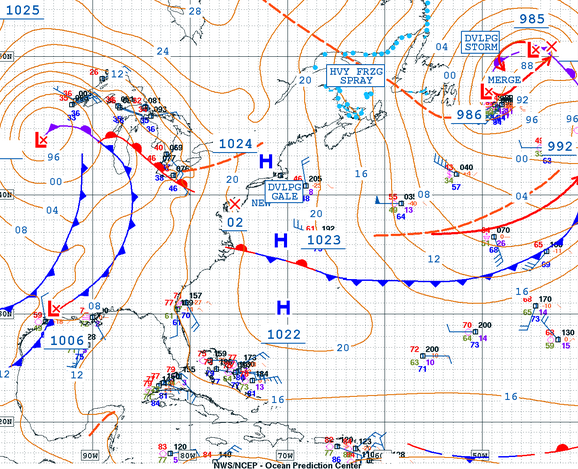
This is not what a weather map looks like when we’re about to go flat. That giant storm far north should supply a steady stream of long period NE swell for most of the coming week. The giant storm currently over the states should provide a steady supply of swell for next week. If the timing works out, we could see some NW swell show up over the weekend but I wouldn’t get too stoked on that scenario yet. If the jetstream pulls that storm too far north we’ll have to wait for it to generate another NE swell and we’ll see no NW push initially. I’m just looking at the positive opportunity since this season has brought several beats on expectations so far. Very consistent surf is fun for everyone. Here’s how I see the week playing out:
Monday should see a strong push of NE long period swell with exposed spots remaining well overhead and tucked away spots with fun head high lines with decent power. Long period swells tend to have a decent amount of wait in between sets which could cause some frustration for the crowded spots.
Tuesday will be very similar to Monday with a slight drop in size and tucked away spots slightly smaller the more tucked away you get. Should still have some chest to head high sets in the water.
Wednesday will still have some head high sets at exposed breaks, but expect fading conditions throughout the day.
Thursday will be surf lessons delight with waist to chest high surf at exposed breaks.
Friday will be pretty much a repeat of Thursday but perhaps a little more consistent.
Saturday might see a new pulse of chest to head high surf with glassy conditions at several Rincon spots.
Sunday is currently forecast to be leftovers from whatever showed up Saturday. Don’t expect more than waist high according to the current forecast, but it wouldn’t take much to shift the forecast up so I wouldn’t be surprised to see this change.
Today
NOAA WaveWatch III Wave Model:

Forecast Swell Period:

Forecast Winds:

Wed
NOAA WaveWatch III Wave Model:

Forecast Swell Period:

Forecast Winds:

Thu
NOAA WaveWatch III Wave Model:

Forecast Swell Period:

Forecast Winds:

Fri
NOAA WaveWatch III Wave Model:

Forecast Swell Period:

Forecast Winds:

Sat
NOAA WaveWatch III Wave Model:

Forecast Swell Period:

Forecast Winds:

Sun
NOAA WaveWatch III Wave Model:

Forecast Swell Period:

Forecast Winds:

Mon
NOAA WaveWatch III Wave Model:

Forecast Swell Period:

Forecast Winds:

Tue
NOAA WaveWatch III Wave Model:

Forecast Swell Period:

Forecast Winds:


